Puerto GuadalTHE PEARL OF LAKE CARRERA, CHILEAN PATAGONIA |
||||||||
 |
||||||||
Where is Puerto Guadal? — how to get there . . . |
||||||||
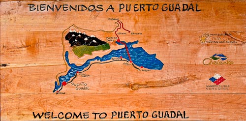
Puerto Guadal is situated on the southwest shore of Lago Carrera, connected to Coyhaique the capital of the 11th Region, or Aysén, by the Carretera Austral, or Southern Highway, an incredibly scenic road. Puerto Guadal is also accessible from Argentina, on Rout 265 from the border crossing between Antiguos and Chile Chico. The approximately 300 kilometers of road between Coyhaique and Puerto Guadal offers an abundance of scenic beauty — this is perhaps the most impressive stretch out of the entire 100 kilometers of the Carretera Austral, a road that many savvy travelers consider the most beautiful scenic road on the planet. |
||||||||
You can use the Google Map to the right to explore the region and the surroundings of Puerto Guadal. You can even open another page with a much larger map by clicking on the link, "View Larger Map." Don't neglect the various options to view the terrain, roads, and satellite photos, accessed by the links: Ter, Map, y Sat. You can also zoom in and out, or navigate the map by means of the controls on its upper left. |
View Larger Map |
|||||||
Puerto Guadal — its streetsBelow you'll see a simplified map of Puerto Guadal. The size and scale of Puerto Guadal invite you to explore it on foot. Distances are short, and the locals, los Guadalinos, are very friendly and helpful. |
||||||||
| BACK TO TOP | 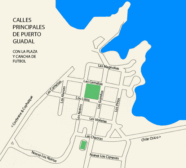 |
|||||||
 |
PUERTO GUADAL
|
|||||||